Mainland Australia: extreme points. Their coordinates and description
Any of the continents has its extreme points. In total there are four of them - northern, western, southern and eastern. The smallest continent in the world is Australia. The extreme points of this continent are four capes, scattered along its long coastline. And each of them has its own story, its interesting features.
Australia: extreme points and features of the geographic location of the continent
The smallest in area and the most isolatedThe continent is compact. The coastline is indented and its total length is almost 36 thousand kilometers. These are the general geographic features of Australia. The extreme points of the continent, namely the northern, eastern and southern, are located approximately at the same distance from each other. The West is significantly removed.

The continent is washed by the waters of the seas of two oceans -Pacific and Indian. To the north of the continent is a large island of New Guinea, and to the south - Tasmania. Along the north-eastern coast of Australia stretches the Great Barrier Reef - a unique natural formation with a length of about 2 thousand kilometers.
Coordinates of the extreme points of Australia
The geographic location of any continent will be incomplete without specifying the location of its extreme points. What are the geographical coordinates of Australia's extreme points?
There are four in all: this is Cape York (northern extreme point), South Point (South), Steep Point (western) and Byron (eastern). The exact coordinates of Australia's extreme points, indicating latitude and longitude, are given below, in the table:
A point on the map | Its coordinates |
Cape York | 10 ° 41'21 "south latitude 142 ° 31'50 "east longitude |
Cape South Point | 39 ° 08'20 "South Latitude 146 ° 22'26 "east longitude |
Cape Steepe Point | 26 ° 09'05 "south latitude 113 ° 09'18 "east longitude |
Cape Byron | 28 ° 38'15 "South Latitude 153 ° 38'14 "east longitude |
The distance between the northern and southern extreme points of Australia is 3,200 kilometers, and between the western and eastern - nearly 4000 kilometers.
Cape York
This cape - the extreme point of Australia in the northcontinent. It is the tip of the Cape York peninsula, which cuts deep enough into the sea. Approximately one and a half hundred kilometers separate Cape York from the coast of New Guinea, the second largest island of our planet.
Administrative cape belongs to the jurisdiction of the stateQueensland. The nearest town of Bamaga is only forty kilometers away. The name of the cape was given by the famous navigator James Cook. During his round-the-world voyage, he skirted the continent from the north and saw a cape sharply protruding into the ocean. Cook named it in honor of the British Duke of York.
On Cape York, if you're lucky, you can observean amazing meteorological phenomenon. This is the so-called morning gloria - a large accumulation of thick white clouds, located at an altitude of about two kilometers. This phenomenon, as a rule, is accompanied by significant jumps of atmospheric pressure. The nature and genesis of this phenomenon are not fully understood.
Cape South Point
This cape is located on the north bank of the Bass Strait, which separates Australia from Tasmania. South Point is within the Wilsons-Promontory National Park.

The cape, and the whole national park, is interesting for those,that here appear as features of the mainland, and features of the island of Tasmania. It is curious that the whole territory of the park was closed for visits during the Second World War, as here the active training of the armed forces of Australia was conducted.
Cape Steepe Point
"Steep Cape" - that's what Steep Point was calledDutch traveler Willem Flumming, who was the first of Europeans to see Australia's extreme western point. In general, it is this name that has survived, having transformed into the English version: Steep Point. Indeed, the coast of the cape is very steep and steep, in some places they reach a height of 150-200 meters.

The nearest settlement is the town of Denham - located 50 kilometers away. Today Cape Steepe Point attracts lovers of fishing from all over the country.
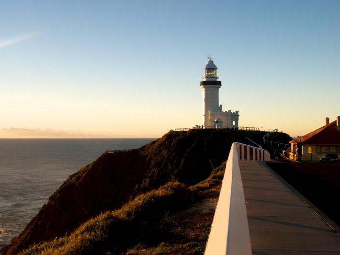
Cape Byron
The extreme eastern point of Australia is anotherthe geographic object of the continent, the name of which was invented by James Cook. He called it cape in 1770 in honor of the British Vice Admiral John Byron (the grandfather of the world-famous poet).
Cape Byron is very often seen in variouslists of Australian places that are recommended first of all to visit tourists. Indeed, he is very handsome and picturesque. The present decoration of the cape is an old lighthouse built in 1901. Near it is an observation deck for tourists, from which you can admire the dolphins, sharks and other inhabitants of the ocean.
Finally…
The smallest and most compact continent on the planet is Australia. The extreme points of the continent are the four capes (York, South Point, Steep Point and Byron).
York is interesting for its local natural miracle -the phenomenon of "Morning Glory". Cape South Point is located in the oldest national park of Victoria. The extreme western point of Australia is interesting in that it is one of the most popular and favorite places for Australian fishermen. But Cape Byron in the east of the continent is named so not at all in honor of the famous British poet (as many believe), but in the name of his grandfather.
</ p>


