Lakes and rivers of the Stavropol Territory
In the valleys of the rivers Kuma, Egorlyk and Kalaus, inthe central part of Ciscaucasia, on the Stavropol Upland, is located Stavropol Territory, which is famous for its resort area of the Caucasian Mineral Waters.
Geography of the Stavropol Territory
The area of Stavropol is 66.16 km², it includes 26 administrative districts with a population of 2.8 million people, of which 58.36% of the urban population (data as of 01.01.2017).
The climate of the region is moderately continental. The terrain is complex. The central part is occupied by the Stavropol Upland, which connects to the foothills of the Greater Caucasus in the south, flows smoothly into the Tersko-Kum lowland and the Azov-Kuban lowland in the west, in the north it joins the Kumo-Manych depression.
In the foothill part you can distinguish the Pyatigorye -volcanic region with numerous peaks. The maximum height is observed in the region of Kislovodsk and reaches 1603 meters above sea level. The smallest peak lies in the lower reaches of the Kuma River. Its height is only 6 meters.

The rivers, lakes and mountains of the Stavropol Territory are originaland picturesque. There are 130 mineral water springs in Stavropol. Water resources of the region are not only nature-created rivers and lakes, but also man-made reservoirs, ponds and canals that are used for moistening arid steppe lands.
The rivers of Stavropol
The rivers of the Stavropol Territory belong to the basinsCaspian and Azov seas. Due to the arid climate on most of the land, the density of the river network is insignificant and unevenly distributed. The most densely situated rivers are in the foothills, and to the east and north their number is significantly reduced. What rivers are there in the Stavropol Territory?
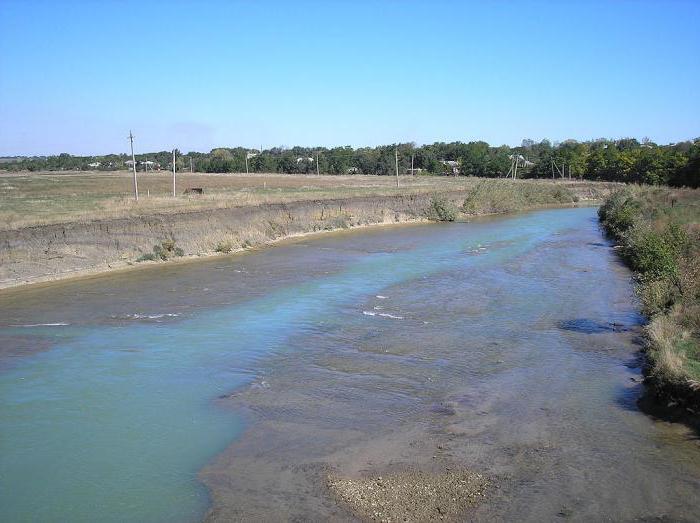
In the Stavropol Territory there are a little more than 200rivers and rivulets. Most of them are small rivers. The length of such rivers is from 101 to 200 km with a catchment area of 1,000 to 2,000 km². The rivers running in the eastern part of the region contain a large number of mineral elements, which is due to the salinity of local soils.
The list of the rivers of the Stavropol Territory can be divided into two parts: rivers belonging to the Azov-Black Sea basin and belonging to the Caspian Sea basin.
The main rivers of the Azov-Black Sea basin
This is the Western Manych, Egorlyk, Kalaus and Kuban. The few rivers of the Stavropol Territory are mainly fed by rain and melting snow. The watershed between the basins of the Azov and Caspian seas, passing from the village of Divnoe through the city of Stavropol, then through Elbrus and the mountains of Beshtau, is a component of the main watershed. The names of the rivers of the Stavropol Territory often have Turkic roots.
Western Manych
The left tributary of the Don is the Western Manych. In translation from the Turkic "Manych" means "bitter". Its source is located in the place of the former fork of the river to the Western and Eastern Manych, the Kalaus River.

Kalaus
This is the second large influx of Western Manych(left). "Kalaus" in translation from the Turkic - "fortress". The river begins on the slopes of Mount Bryk and flows along the Stavropol Upland. Its length is 436 km. The river feeds from springs, melted snow and rains. The banks are steep and steep, sometimes reaching a height of 15 m. Kalaus has 81 tributaries. In the immediate vicinity of the source are Maikop clays, because of which the river's water is muddy, salty and not suitable for drinking.
Egorlyk
The Egorlyk river of the Stavropol Territory is the left tributary of the Western Manych. Its source is on Mount Stryzhament.
Kuban
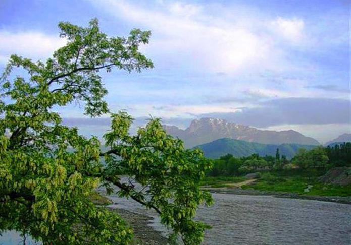
The Kuban River is the largest river in the Stavropolthe edges. Its source is the western slope of Mount Elbrus, where the Uchkulan and Ullukam rivers merge. The length of the Kuban River is about 870 km. The route of its current passes through Karachaevo-Cherkessia in Stavropol, then - to the border of Krasnodar region with Adygea, it flows into the Azov Sea. The waters of the river are used for drinking and irrigation.

The largest influx of the Kuban is the GreatZelenchuk. The highest rise in water level can be observed in the second half of summer. Filling of the riverbed of the Kuban takes place due to rains, melted waters, including from mountain glaciers, underground currents. In the Stavropol Territory, the river is mainly fed by rainwater. The main rivers of the Caspian Sea basin are Terek, Kuma, Gorkaya Balka, Vostochny Manych.
Terek
The source of this river is the Stavropol TerritoryTrusov Gorge, located on the Main Caucasian ridge. The length of the Terek river bed is 623 km. The river flows from Georgia to North Ossetia, then through the territory of Kabardino-Balkaria and the Stavropol Territory, through Chechnya and Dagestan into the Agrakhan Gulf of the Caspian Sea. Its main inflow is Malka.
East Manych
The source and feeding sources are the same as inWestern Manych. The length is 141 km. After human intervention, the river Kalaus no longer replenishes the East Manych, but only the Western. Flows through the territory of Kalmykia and Stavropol. Before the Caspian Sea, the river flows through the Sostinsky lakes. Water quality is low, it can not be used for drinking.
Kuma
The source of Kuma lies on the northern slope of the Rockyridge in the Karachaevo-Cherkessia. Its length is 809 km. The food for the river is for the most part rainfall and groundwater. Sometimes due to lack of precipitation, Kuma does not reach the Caspian Sea. The river feeds on its waters the Kuma valley. Its tributaries are Wet and Dry Karamik, Zolka, Podkumok, Tomuzlovka, Wet Buffalo.
Bitter Beam
The sources of this river are the springs of Georgievsky district. Its length is 183 km. The tributary of the Gorkaya Balka River is Dry Gorkaya.
Lakes of the Stavropol Territory
Stavropol can not boast of greatnumber of lakes. They are only 38, but among them you can find a variety of characteristics, unusual, rich in fish and mud mud lakes.
One of such unusual lakes in the Stavropol region is a karst lake. A failure of pure blue color, which invariably attracts a large number of tourists.

The Stavropol region is famous for its saltylakes, which by the quality of therapeutic mud can compete with the Dead Sea. In Lushnikovskoe lake near Svetlograd, for example, once the army commander, Budyonny treated his men from wounds.
One of the most popular lakes of Stavropolis considered the medical lake Tambukan, which is located on the border of Stavropol and Kabardino-Balkaria. In the name of the lake, the name of the great Kabardian prince, who was the ancestor of the ancient Tambiev family, was immortalized.

But most of all the Stavropol Rivers are famous for theirfishing. Lake Dovsun and the Chograiskoye reservoir, located in the Arzgir district, are extremely popular with fishermen from all over Russia and are famous for the variety of fish species.
Sengileevsky Lake is also aA reservoir that supplies fresh water to the marginal center. Once it was called Fish and was not too deep. But then, in 1958, after the construction of the dam, the water level in it rose so much that its depth became almost like in the Azov Sea.
Another popular in the fishermen's lake is the lakeGreat, which is on the border with Kalmykia. Such lakes of Stavropol, as Beloe, Manych-Gudilo, Bald Liman, Maly Manych, Manych, are also known as fish.
Very attracted by amateurs for fishing relicLake Kravtsovo, which is considered a natural mystery of the Stavropol Territory. This lake can overgrow and self-clean. The causes of this phenomenon have not yet been discovered by scientists. Lake Kravtsovo is also very rich in peat.
You can read the description of the Stavropol Territory for a long time,its rivers, lakes, boundless steppes and magnificent mountain landscapes, but nothing will replace a personal presence. It is better to see everything with your own eyes. The rivers and lakes of the Stavropol Territory - this is something that should definitely be looked at.
</ p>


